
Doe een donatie
Rust jezelf uit voor je volgende avontuur:
Als Amazon-partner verdient deze site een commissie op in aanmerking komende aankopen, zonder extra kosten voor jou.
Topografische kaart Estang
Klik op de kaart om de hoogte weer te geven.
Doe een donatie
Rust jezelf uit voor je volgende avontuur:
Als Amazon-partner verdient deze site een commissie op in aanmerking komende aankopen, zonder extra kosten voor jou.
Estang
Several studies have been conducted to characterize the climatic types to which the national territory is exposed. The resulting zoning varies depending on the methods used, the nature and number of parameters considered, the territorial coverage of the data, and the reference period. In 2010, the commune's climate was classified as an altered oceanic climate, according to a study by the French National Centre for Scientific Research (CNRS) based on a method combining climatic data and environmental factors (topography, land use, etc.) and data covering the period 1971-2000. In 2020, the predominant climate was classified as Cfb, according to the Köppen-Geiger classification, for the period 1988-2017, namely a temperate climate with cool summers and no dry season. Furthermore, in 2020, Météo-France published a new typology of the climates of metropolitan France, in which the commune is exposed to a modified oceanic climate and is located in the Aquitaine-Gascogne climatic region, characterized by abundant rainfall in spring, moderate rainfall in autumn, low sunshine in spring, hot summers (19.5°C), weak winds, frequent fog in autumn and winter, and frequent thunderstorms in summer (15 to 20 days). It is also located in zone H2c under the 2020 environmental regulations for new construction.
Doe een donatie
Rust jezelf uit voor je volgende avontuur:
Als Amazon-partner verdient deze site een commissie op in aanmerking komende aankopen, zonder extra kosten voor jou.
Over deze kaart
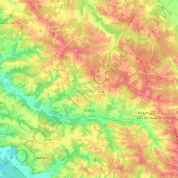
Naam: Topografische kaart Estang, hoogte, reliëf.
Gemiddelde hoogte: 121 m
Minimale hoogte: 67 m
Maximale hoogte: 163 m
Doe een donatie
Rust jezelf uit voor je volgende avontuur:
Als Amazon-partner verdient deze site een commissie op in aanmerking komende aankopen, zonder extra kosten voor jou.
Andere topografische kaarten
Klik op een kaart om zijn topografie, zijn hoogte en zijn reliëf te bekijken.
Doe een donatie
Rust jezelf uit voor je volgende avontuur:
Als Amazon-partner verdient deze site een commissie op in aanmerking komende aankopen, zonder extra kosten voor jou.