
Doe een donatie
Rust jezelf uit voor je volgende avontuur:
Als Amazon-partner verdient deze site een commissie op in aanmerking komende aankopen, zonder extra kosten voor jou.
Topografische kaart Pottsville
Klik op de kaart om de hoogte weer te geven.
Doe een donatie
Rust jezelf uit voor je volgende avontuur:
Als Amazon-partner verdient deze site een commissie op in aanmerking komende aankopen, zonder extra kosten voor jou.
Pottsville
Pottsville experiences a humid subtropical climate (Cfa) according to the Köppen climate classification system if the 26.6 °F (−3.0 °C) isotherm is used, or a humid continental climate (Dfa) if the 32 °F (0 °C) isotherm is used. The record high was 104 °F (40 °C) in 2011, and the record low was −19 °F (−28 °C) in 1994. Average monthly temperatures range from 27.3 °F in January to 72.3 °F in July. [2] The hardiness zone is 6b or 7a depending upon elevation. [3]
Doe een donatie
Rust jezelf uit voor je volgende avontuur:
Als Amazon-partner verdient deze site een commissie op in aanmerking komende aankopen, zonder extra kosten voor jou.
Over deze kaart
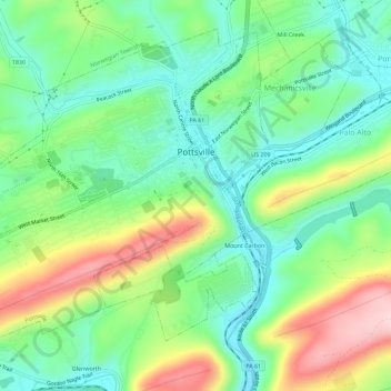
Naam: Topografische kaart Pottsville, hoogte, reliëf.
Gemiddelde hoogte: 262 m
Minimale hoogte: 174 m
Maximale hoogte: 426 m
Doe een donatie
Rust jezelf uit voor je volgende avontuur:
Als Amazon-partner verdient deze site een commissie op in aanmerking komende aankopen, zonder extra kosten voor jou.
Andere topografische kaarten
Klik op een kaart om zijn topografie, zijn hoogte en zijn reliëf te bekijken.
Park Place
United States > Pennsylvania > Schuylkill County > Mahanoy Township
Gemiddelde hoogte: 515 m
Andreas
United States > Pennsylvania > Schuylkill County > West Penn Township
Gemiddelde hoogte: 250 m
Doe een donatie
Rust jezelf uit voor je volgende avontuur:
Als Amazon-partner verdient deze site een commissie op in aanmerking komende aankopen, zonder extra kosten voor jou.
Blue Mountain
United States > Pennsylvania > Schuylkill County > Washington Township
The ridge of Blue Mountain runs for 150 miles (240 km) through Pennsylvania, reaching an elevation of 2,270 feet (690 m) above sea level just north of the Pennsylvania Turnpike, near the borough of Newburg. Most of the ridgecrest, however, only reaches between 1,400 and 1,700 feet (430 and 520 m) in elevation.…
Gemiddelde hoogte: 226 m
Snyders
United States > Pennsylvania > Schuylkill County > West Penn Township
Gemiddelde hoogte: 242 m
Andreas
United States > Pennsylvania > Schuylkill County > West Penn Township
Gemiddelde hoogte: 250 m
Doe een donatie
Rust jezelf uit voor je volgende avontuur:
Als Amazon-partner verdient deze site een commissie op in aanmerking komende aankopen, zonder extra kosten voor jou.
Blue Mountain
United States > Pennsylvania > Schuylkill County > Washington Township
The ridge of Blue Mountain runs for 150 miles (240 km) through Pennsylvania, reaching an elevation of 2,270 feet (690 m) above sea level just north of the Pennsylvania Turnpike, near the borough of Newburg. Most of the ridgecrest, however, only reaches between 1,400 and 1,700 feet (430 and 520 m) in elevation.…
Gemiddelde hoogte: 226 m
Irving
United States > Pennsylvania > Schuylkill County > Pine Grove Township
Gemiddelde hoogte: 199 m
Doe een donatie
Rust jezelf uit voor je volgende avontuur:
Als Amazon-partner verdient deze site een commissie op in aanmerking komende aankopen, zonder extra kosten voor jou.
Blue Mountain
United States > Pennsylvania > Schuylkill County > Washington Township
The ridge of Blue Mountain runs for 150 miles (240 km) through Pennsylvania, reaching an elevation of 2,270 feet (690 m) above sea level just north of the Pennsylvania Turnpike, near the borough of Newburg. Most of the ridgecrest, however, only reaches between 1,400 and 1,700 feet (430 and 520 m) in elevation.…
Gemiddelde hoogte: 226 m
Nuremberg
United States > Pennsylvania > Schuylkill County > North Union Township
Gemiddelde hoogte: 377 m