
Doe een donatie
Rust jezelf uit voor je volgende avontuur:
Als Amazon-partner verdient deze site een commissie op in aanmerking komende aankopen, zonder extra kosten voor jou.
Topografische kaart Monte Pissis
Klik op de kaart om de hoogte weer te geven.
Doe een donatie
Rust jezelf uit voor je volgende avontuur:
Als Amazon-partner verdient deze site een commissie op in aanmerking komende aankopen, zonder extra kosten voor jou.
Monte Pissis
A 1994 Argentine expedition claimed —using GPS technology available at the time— that the elevation of Monte Pissis was 6,882 m (22,579 ft), higher than Ojos del Salado. Ten years later, with the use of higher precision systems, several other surveys proved that those measurements were inaccurate: in 2005, an Austrian team performed a DGPS survey of Pissis' summit and found the elevation to be 6,793 m (22,287 ft). In 2006 an international expedition surveyed the height on the summit, and found results in agreement with an elevation around 6,800 m (22,300 ft). This was later confirmed by a 2007 Chilean-Argentine-European expedition, which surveyed both Ojos del Salado and Monte Pissis and provisionally found the former to be 6,891 m (22,608 ft) and the latter 6,793 m (22,287 ft).
Doe een donatie
Rust jezelf uit voor je volgende avontuur:
Als Amazon-partner verdient deze site een commissie op in aanmerking komende aankopen, zonder extra kosten voor jou.
Over deze kaart
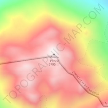
Naam: Topografische kaart Monte Pissis, hoogte, reliëf.
Gemiddelde hoogte: 6.465 m
Minimale hoogte: 5.872 m
Maximale hoogte: 6.791 m
Doe een donatie
Rust jezelf uit voor je volgende avontuur:
Als Amazon-partner verdient deze site een commissie op in aanmerking komende aankopen, zonder extra kosten voor jou.