
Topografische kaart Edmonson County
Interactieve kaart
Klik op de kaart om de hoogte weer te geven.
Over deze kaart
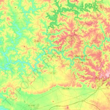
Naam: Topografische kaart Edmonson County, hoogte, reliëf.
Locatie: Edmonson County, Kentucky, VS (37.05312 -86.46872 37.34086 -86.04896)
Gemiddelde hoogte: 196 m
Minimale hoogte: 123 m
Maximale hoogte: 300 m
Andere topografische kaarten
Klik op een kaart om zijn topografie, zijn hoogte en zijn reliëf te bekijken.
Bowling Green
VS > Kentucky > Bowling Green
Bowling Green, Warren County, Kentucky, 42101, VS
Gemiddelde hoogte: 169 m
Abraham Lincoln Birthplace National Historic Site
VS > Kentucky > Boundary Oak
Abraham Lincoln Birthplace National Historic Site, Boundary Oak, Larue County, Kentucky, VS
Gemiddelde hoogte: 238 m
Nationaal park Mammoth Cave
VS > Kentucky > Mammoth Cave
Nationaal park Mammoth Cave, Green River Ferry Road, Mammoth Cave, Edmonson County, Kentucky, VS
Gemiddelde hoogte: 215 m
Louisville
VS > Kentucky > Louisville
Louisville, Jefferson County, Kentucky, VS
Gemiddelde hoogte: 188 m
Hodgenville
VS > Kentucky > Hodgenville
Hodgenville, Larue County, Kentucky, VS
Gemiddelde hoogte: 229 m