
Topografische kaart Bald Peak State Scenic Viewpoint
Interactieve kaart
Klik op de kaart om de hoogte weer te geven.
Over deze kaart
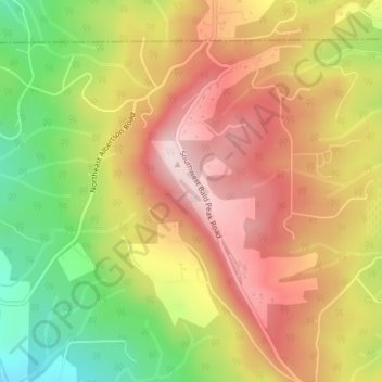
Naam: Topografische kaart Bald Peak State Scenic Viewpoint, hoogte, reliëf.
Gemiddelde hoogte: 334 m
Minimale hoogte: 129 m
Maximale hoogte: 503 m
Bald Peak is on top of the Chehalem Mountains at an elevation of 1,629 feet (497 m) above sea level, the highest point in the mountain range. The closest community to the 26-acre (11 ha) park is Laurelwood, Oregon, with the park generally situated between the cities of Hillsboro to the north and Newberg to the south near the county boundary line between Yamhill and Washington counties. At the park are restrooms, picnic tables, parking, a trail, a forest with Douglas fir trees, but no drinking water. In clear weather, the park offers views of Mount Hood, Mount St. Helens, Mount Jefferson, Mount Adams, and Mount Rainier. The viewpoint also gives panoramas of the Tualatin Valley to the north of the park and the Yamhill Valley to the south, with both valleys being parts of the larger Willamette Valley.
Andere topografische kaarten
Klik op een kaart om zijn topografie, zijn hoogte en zijn reliëf te bekijken.
McMinnville
United States > Oregon > Yamhill County
McMinnville, Yamhill County, Oregon, 97128, United States
Gemiddelde hoogte: 50 m
Newberg
United States > Oregon > Yamhill County
Newberg, Yamhill County, Oregon, United States
Gemiddelde hoogte: 61 m
Amity Hills
United States > Oregon > Yamhill County > Amity
Amity Hills, Amity, Yamhill County, Oregon, United States
Gemiddelde hoogte: 108 m
Sheridan
United States > Oregon > Yamhill County
Sheridan, Yamhill County, Oregon, United States
Gemiddelde hoogte: 85 m
Lafayette
United States > Oregon > Yamhill County
Lafayette, Yamhill County, Oregon, 97127, United States
Gemiddelde hoogte: 52 m
McGuire Reservoir
United States > Oregon > Yamhill County
McGuire Reservoir, Yamhill County, Oregon, United States
Gemiddelde hoogte: 582 m
Carlton
United States > Oregon > Yamhill County
Carlton, Yamhill County, Oregon, 97111, United States
Gemiddelde hoogte: 51 m
Amity
United States > Oregon > Yamhill County
Amity, Yamhill County, Oregon, United States
Gemiddelde hoogte: 51 m
Dayton
United States > Oregon > Yamhill County
Dayton, Yamhill County, Oregon, United States
Gemiddelde hoogte: 43 m
Dundee
United States > Oregon > Yamhill County
Dundee, Yamhill County, Oregon, 97115, United States
Gemiddelde hoogte: 69 m
Willamina
United States > Oregon > Yamhill County > Willamina
Willamina, Yamhill County, Oregon, United States
Gemiddelde hoogte: 93 m
Yamhill
United States > Oregon > Yamhill County > Yamhill
Yamhill, Yamhill County, Oregon, United States
Gemiddelde hoogte: 55 m
Tetons
United States > Oregon > Yamhill County
Tetons, Yamhill County, Oregon, United States
Gemiddelde hoogte: 406 m