
Topografische kaart Clarksdale
Interactieve kaart
Klik op de kaart om de hoogte weer te geven.
Over deze kaart
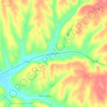
Naam: Topografische kaart Clarksdale, hoogte, reliëf.
Locatie: Clarksdale, Brown County, Indiana, United States (39.18005 -86.14610 39.22005 -86.10610)
Gemiddelde hoogte: 242 m
Minimale hoogte: 192 m
Maximale hoogte: 288 m
Andere topografische kaarten
Klik op een kaart om zijn topografie, zijn hoogte en zijn reliëf te bekijken.
Helmsburg
United States > Indiana > Brown County
Helmsburg, Brown County, Indiana, 47435, United States
Gemiddelde hoogte: 222 m
Story
United States > Indiana > Brown County
Story, Brown County, Indiana, United States
Gemiddelde hoogte: 195 m
Pikes Peak
United States > Indiana > Brown County
Pikes Peak, Brown County, Indiana, United States
Gemiddelde hoogte: 219 m
Needmore
United States > Indiana > Brown County
Needmore, Brown County, Indiana, 47435, United States
Gemiddelde hoogte: 223 m
Gnaw Bone
United States > Indiana > Brown County
Gnaw Bone, Brown County, Indiana, United States
Gemiddelde hoogte: 231 m
Becks Grove
United States > Indiana > Brown County
Becks Grove, Brown County, Indiana, United States
Gemiddelde hoogte: 239 m
Christiansburg
United States > Indiana > Brown County
Christiansburg, Brown County, Indiana, United States
Gemiddelde hoogte: 217 m
Fruitdale
United States > Indiana > Brown County
Fruitdale, Brown County, Indiana, 46160, United States
Gemiddelde hoogte: 247 m
Camp Roberts
United States > Indiana > Brown County
Camp Roberts, Brown County, Indiana, United States
Gemiddelde hoogte: 226 m
Cornelius
United States > Indiana > Brown County
Cornelius, Brown County, Indiana, 47435, United States
Gemiddelde hoogte: 242 m
Mount Liberty
United States > Indiana > Brown County
Mount Liberty, Brown County, Indiana, United States
Gemiddelde hoogte: 241 m
Lanam
United States > Indiana > Brown County
Lanam, Brown County, Indiana, 47435, United States
Gemiddelde hoogte: 242 m
Belmont
United States > Indiana > Brown County
Belmont, Brown County, Indiana, United States
Gemiddelde hoogte: 196 m
Elkinsville
United States > Indiana > Brown County
Elkinsville, Brown County, Indiana, United States
Gemiddelde hoogte: 200 m
Gatesville
United States > Indiana > Brown County
Gatesville, Brown County, Indiana, United States
Gemiddelde hoogte: 238 m
Peoga
United States > Indiana > Brown County
Peoga, Brown County, Indiana, 46164, United States
Gemiddelde hoogte: 280 m
Stone Head
United States > Indiana > Brown County
Stone Head, Brown County, Indiana, United States
Gemiddelde hoogte: 214 m
Spearsville
United States > Indiana > Brown County
Spearsville, Brown County, Indiana, United States
Gemiddelde hoogte: 271 m
Kirkofer Lake Dam
United States > Indiana > Brown County
Kirkofer Lake Dam, Brown County, Indiana, United States
Gemiddelde hoogte: 241 m
Trevlac
United States > Indiana > Brown County
Trevlac, Brown County, Indiana, 47435, United States
Gemiddelde hoogte: 214 m
Taggart
United States > Indiana > Brown County
Taggart, Brown County, Indiana, United States
Gemiddelde hoogte: 237 m
Beanblossom
United States > Indiana > Brown County
Beanblossom, Brown County, Indiana, 47435, United States
Gemiddelde hoogte: 233 m
Nashville
United States > Indiana > Brown County
Nashville, Brown County, Indiana, United States
Gemiddelde hoogte: 208 m