
Topografische kaart Hiriyur
Interactieve kaart
Klik op de kaart om de hoogte weer te geven.
Over deze kaart
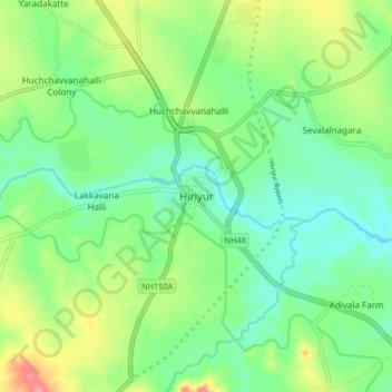
Naam: Topografische kaart Hiriyur, hoogte, reliëf.
Gemiddelde hoogte: 613 m
Minimale hoogte: 585 m
Maximale hoogte: 668 m
Hiriyur is located at 13°57′N 76°37′E / 13.95°N 76.62°E / 13.95; 76.62. It has an average elevation of 630 metres (2066 feet). The months of March and April are the hottest months of the year.