
Bedankt voor het steunen van deze site ❤️
Doe een donatie
Doe een donatie
Rust jezelf uit voor je volgende avontuur:
Als Amazon-partner verdient deze site een commissie op in aanmerking komende aankopen, zonder extra kosten voor jou.
Topografische kaart Chambon
Klik op de kaart om de hoogte weer te geven.
Bedankt voor het steunen van deze site ❤️
Doe een donatie
Doe een donatie
Rust jezelf uit voor je volgende avontuur:
Als Amazon-partner verdient deze site een commissie op in aanmerking komende aankopen, zonder extra kosten voor jou.
Over deze kaart
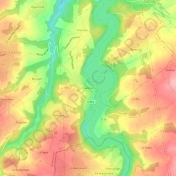
Naam: Topografische kaart Chambon, hoogte, reliëf.
Gemiddelde hoogte: 243 m
Minimale hoogte: 163 m
Maximale hoogte: 306 m
Bedankt voor het steunen van deze site ❤️
Doe een donatie
Doe een donatie
Rust jezelf uit voor je volgende avontuur:
Als Amazon-partner verdient deze site een commissie op in aanmerking komende aankopen, zonder extra kosten voor jou.
Andere topografische kaarten
Klik op een kaart om zijn topografie, zijn hoogte en zijn reliëf te bekijken.