
Topografische kaart Feura Bush
Interactieve kaart
Klik op de kaart om de hoogte weer te geven.
Over deze kaart
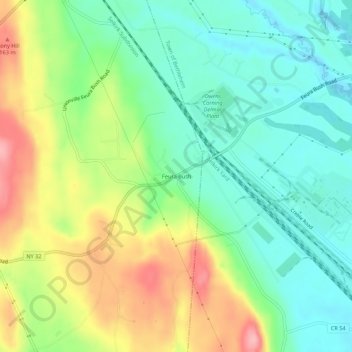
Naam: Topografische kaart Feura Bush, hoogte, reliëf.
Gemiddelde hoogte: 95 m
Minimale hoogte: 44 m
Maximale hoogte: 181 m
Andere topografische kaarten
Klik op een kaart om zijn topografie, zijn hoogte en zijn reliëf te bekijken.
Wolf Hill
United States > New York > Albany County > Town of New Scotland
Wolf Hill, Town of New Scotland, Albany County, New York, 12041, United States
Gemiddelde hoogte: 385 m
Unionville
United States > New York > Albany County > Town of New Scotland
Unionville, Town of New Scotland, Albany County, New York, 12067, United States
Gemiddelde hoogte: 88 m
Tarrytown
United States > New York > Albany County > Town of New Scotland
Tarrytown, Town of New Scotland, Albany County, New York, 12041, United States
Gemiddelde hoogte: 222 m
Clarksville
United States > New York > Albany County > Town of New Scotland
Clarksville, Town of New Scotland, Albany County, New York, 12041, United States
Gemiddelde hoogte: 243 m
New Salem
United States > New York > Albany County > Town of New Scotland
New Salem, Town of New Scotland, Albany County, New York, 12186, United States
Gemiddelde hoogte: 212 m
John Boyd Thacher State Park
United States > New York > Albany County > Town of New Scotland
John Boyd Thacher State Park, Town of New Scotland, Albany County, New York, United States
Gemiddelde hoogte: 262 m
Village of Voorheesville
United States > New York > Albany County > Town of New Scotland
Village of Voorheesville, Town of New Scotland, Albany County, New York, 12186, United States
Gemiddelde hoogte: 107 m