
Topografische kaart Glenwood
Interactieve kaart
Klik op de kaart om de hoogte weer te geven.
Over deze kaart
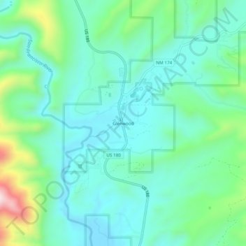
Naam: Topografische kaart Glenwood, hoogte, reliëf.
Locatie: Glenwood, Catron County, New Mexico, 88039, United States (33.29599 -108.90281 33.33599 -108.86281)
Gemiddelde hoogte: 1.526 m
Minimale hoogte: 1.415 m
Maximale hoogte: 1.895 m
Andere topografische kaarten
Klik op een kaart om zijn topografie, zijn hoogte en zijn reliëf te bekijken.
Quemado
United States > New Mexico > Catron County
Quemado, Catron County, New Mexico, 87829, United States
Gemiddelde hoogte: 2.113 m
San Francisco
United States > New Mexico > Catron County
San Francisco, Catron County, New Mexico, United States
Gemiddelde hoogte: 2.440 m
Zuni Salt Lake
United States > New Mexico > Catron County > Salt Lake
Zuni Salt Lake, Salt Lake, Catron County, New Mexico, United States
Gemiddelde hoogte: 1.940 m
Pie Town
United States > New Mexico > Catron County
Pie Town, Catron County, New Mexico, 87827, United States
Gemiddelde hoogte: 2.352 m