
Topografische kaart Trikala Municipality
Interactieve kaart
Klik op de kaart om de hoogte weer te geven.
Over deze kaart
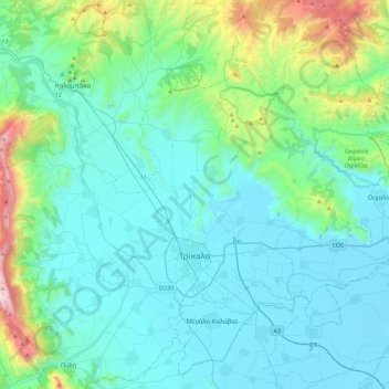
Naam: Topografische kaart Trikala Municipality, hoogte, reliëf.
Gemiddelde hoogte: 350 m
Minimale hoogte: 88 m
Maximale hoogte: 1.801 m
Andere topografische kaarten
Klik op een kaart om zijn topografie, zijn hoogte en zijn reliëf te bekijken.
Meteora
Greece > Thessaly and Central Greece > Trikala Regional Unit > Kastraki
Meteora, Kastraki, Meteora Municipality, Trikala Regional Unit, Thessaly, Thessaly and Central Greece, 422 00, Greece
Gemiddelde hoogte: 429 m
Servota
Greece > Thessaly and Central Greece > Trikala Regional Unit
Servota, Farkadona Municipality, Trikala Regional Unit, Thessaly, Thessaly and Central Greece, 430 61, Greece
Gemiddelde hoogte: 95 m
Trikala
Greece > Thessaly and Central Greece > Trikala Regional Unit
Trikala, Trikala Municipality, Trikala Regional Unit, Thessaly, Thessaly and Central Greece, 421 00, Greece
Gemiddelde hoogte: 247 m
Pyrgos Kalabakas (Tower of Kalabaka)
Greece > Thessaly and Central Greece > Trikala Regional Unit > Kalabaka
Pyrgos Kalabakas (Tower of Kalabaka), Kalabaka, Meteora Municipality, Trikala Regional Unit, Thessaly, Thessaly and Central Greece, 422 00, Greece
Gemiddelde hoogte: 336 m
Farkadona
Greece > Thessaly and Central Greece > Trikala Regional Unit
Farkadona, Farkadona Municipality, Trikala Regional Unit, Thessaly, Thessaly and Central Greece, 420 31, Greece
Gemiddelde hoogte: 137 m
Devil's tower
Greece > Thessaly and Central Greece > Trikala Regional Unit > Καλαμπάκα
Devil's tower, Καλαμπάκα, Meteora Municipality, Trikala Regional Unit, Thessaly, Thessaly and Central Greece, 422 00, Greece
Gemiddelde hoogte: 414 m