
Topografische kaart Hodges
Interactieve kaart
Klik op de kaart om de hoogte weer te geven.
Over deze kaart
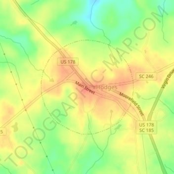
Naam: Topografische kaart Hodges, hoogte, reliëf.
Locatie: Hodges, Greenwood County, South Carolina, United States (34.28027 -82.25660 34.29491 -82.23926)
Gemiddelde hoogte: 200 m
Minimale hoogte: 173 m
Maximale hoogte: 217 m
Andere topografische kaarten
Klik op een kaart om zijn topografie, zijn hoogte en zijn reliëf te bekijken.
Canterbury
United States > South Carolina > Greenwood County
Canterbury, Greenwood County, South Carolina, 29649, United States
Gemiddelde hoogte: 187 m
Lake Greenwood
United States > South Carolina > Greenwood County > Dyson
Lake Greenwood, Dyson, Greenwood County, South Carolina, United States
Gemiddelde hoogte: 160 m
Ninety Six National Historic Site
United States > South Carolina > Greenwood County
Ninety Six National Historic Site, Greenwood County, South Carolina, United States
Gemiddelde hoogte: 144 m
Ninety Six
United States > South Carolina > Greenwood County
Ninety Six, Greenwood County, South Carolina, United States
Gemiddelde hoogte: 162 m
Promised Land
United States > South Carolina > Greenwood County > Promised Land
Promised Land, Greenwood County, South Carolina, United States
Gemiddelde hoogte: 177 m
Friendship
United States > South Carolina > Greenwood County
Friendship, Greenwood County, South Carolina, United States
Gemiddelde hoogte: 167 m