
Topografische kaart Jericho
Klik op de kaart om de hoogte weer te geven.
Over deze kaart
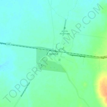
Naam: Topografische kaart Jericho, hoogte, reliëf.
Locatie: Jericho, Barcaldine Regional, Queensland, 4628, Australia (-23.64364 146.08415 -23.56364 146.16415)
Gemiddelde hoogte: 351 m
Minimale hoogte: 343 m
Maximale hoogte: 377 m
Andere topografische kaarten
Klik op een kaart om zijn topografie, zijn hoogte en zijn reliëf te bekijken.
City of Brisbane
Brisbane's topography is characterized by a series of hills and ranges that define its landscape. The city is situated on a low-lying floodplain, with the Brisbane River meandering through its heart, creating a winding course with many steep curves from the southwest to its mouth at Moreton Bay in the east.…
Gemiddelde hoogte: 71 m
Lama Lama National Park (Cape York Peninsula Aboriginal Land)
Gemiddelde hoogte: 86 m
Sunshine Coast Regional
The Sunshine Coast Regional area in Queensland, Australia, features a diverse topography that ranges from coastal plains to rugged hinterlands. Along the coastline, the terrain is predominantly flat, with average elevations around 20 meters (66 feet) above sea level. Inland, the landscape transitions to…
Gemiddelde hoogte: 56 m
Brisbane River
The RAAF also perform a practice session in the days preceding the event, serving as an opportunity to both practice beforehand and also promote Riverfire. One of the most popular RAAF aircraft to perform at Riverfire was the F-111 which was known for performing a 'dump-and-burn' above the city. The final…
Gemiddelde hoogte: 235 m
Lamb Island
The island is in the southern part of Moreton Bay between the Queensland mainland and North Stradbroke Island. It is within the Moreton Bay Marine Park. The elevation ranges from 0 to 26 metres (0 to 85 ft) above sea level. The land use on the island is predominantly residential.
Gemiddelde hoogte: 4 m
Alexandra Hills
Scribbly Gums Conservation Area is located on the eastern edge of Alexandra Hills, bordered by Redland Hospital to the east, and Flinders St and Winchester Rd to the north. The conservation area occupies approximately 152 hectares and contains the Redlands Track Park - a collection of 30+ mountain bike trails…
Gemiddelde hoogte: 34 m