
Topografische kaart Pinewood
Interactieve kaart
Klik op de kaart om de hoogte weer te geven.
Over deze kaart
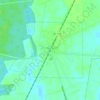
Naam: Topografische kaart Pinewood, hoogte, reliëf.
Locatie: Pinewood, Sumter County, South Carolina, United States (33.73226 -80.47682 33.74749 -80.45271)
Gemiddelde hoogte: 57 m
Minimale hoogte: 52 m
Maximale hoogte: 63 m
Andere topografische kaarten
Klik op een kaart om zijn topografie, zijn hoogte en zijn reliëf te bekijken.
Poinsett State Park
United States > South Carolina > Sumter County
Poinsett State Park, Sumter County, South Carolina, United States
Gemiddelde hoogte: 54 m
Ranchland Ranchettes
United States > South Carolina > Sumter County
Ranchland Ranchettes, Sumter County, South Carolina, 29153, United States
Gemiddelde hoogte: 45 m
South Sumter
United States > South Carolina > Sumter County > Shannontown
South Sumter, Shannontown, Sumter County, South Carolina, United States
Gemiddelde hoogte: 43 m
Wedgewood
United States > South Carolina > Sumter County > Wedgefield > Wedgewood
Wedgewood, Wedgefield, Sumter County, South Carolina, United States
Gemiddelde hoogte: 61 m
Dalzell
United States > South Carolina > Sumter County
Dalzell, Sumter County, South Carolina, 29040, United States
Gemiddelde hoogte: 74 m
Wedgefield
United States > South Carolina > Sumter County
Wedgefield, Sumter County, South Carolina, 29168, United States
Gemiddelde hoogte: 72 m
Rembert
United States > South Carolina > Sumter County
Rembert, Sumter County, South Carolina, United States
Gemiddelde hoogte: 63 m