
Topografische kaart South Taft
Interactieve kaart
Klik op de kaart om de hoogte weer te geven.
Over deze kaart
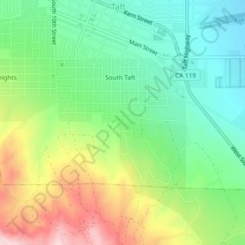
Naam: Topografische kaart South Taft, hoogte, reliëf.
Locatie: South Taft, Taft, Kern County, California, United States (35.12245 -119.47272 35.13691 -119.44730)
Gemiddelde hoogte: 343 m
Minimale hoogte: 249 m
Maximale hoogte: 502 m
South Taft is a census-designated place (CDP) in Kern County, California, United States. South Taft is located 0.5 miles (0.8 km) south of Taft, at an elevation of 1,017 feet (310 m). The population was 2,169 at the 2010 census, up from 1,898 at the time of the 2000 census.