
Topografische kaart El Torno
Interactieve kaart
Klik op de kaart om de hoogte weer te geven.
Over deze kaart
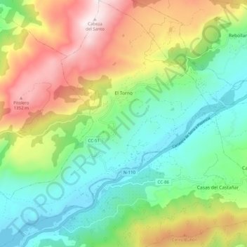
Naam: Topografische kaart El Torno, hoogte, reliëf.
Locatie: El Torno, Valle del Jerte, Cáceres, Extremadura, Spain (40.08895 -6.00005 40.16455 -5.91007)
Gemiddelde hoogte: 769 m
Minimale hoogte: 361 m
Maximale hoogte: 1.479 m
El Torno is a small village at the west of Spain. It is a mountains village, and has a river named Jerte. The village is at 900 m altitude. The main monument is an old church. It is an agriculture village, and its main fruit is the cherry. It is rainy and has much forest. The more important holiday is San Lucas on October 18, and also the Carnival is very important.[citation needed]