Geolokaliseren

Topografische kaart Quaking Houses

Interactieve kaart

Klik op de kaart om de hoogte weer te geven.

Over deze kaart

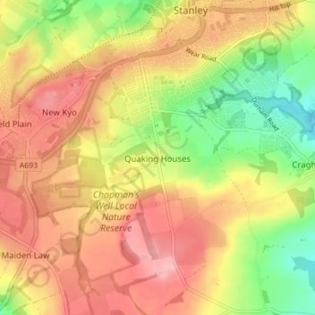
Naam: Topografische kaart Quaking Houses, hoogte, reliëf.

Locatie: Quaking Houses, Stanley, County Durham, North East, England, DH9 7EY, United Kingdom (54.83348 -1.72366 54.87348 -1.68366)

Gemiddelde hoogte: 206 m

Minimale hoogte: 131 m

Maximale hoogte: 266 m

Andere topografische kaarten

Klik op een kaart om zijn topografie, zijn hoogte en zijn reliëf te bekijken.

Tanfield

United Kingdom > England > County Durham > Stanley > Sleepy Valley

Tanfield, Sleepy Valley, Stanley, County Durham, North East, England, DH9 9PX, United Kingdom

Gemiddelde hoogte: 178 m

Greencroft

United Kingdom > England > County Durham > Stanley

Greencroft, Stanley, County Durham, North East, England, DH9 8NQ, United Kingdom

Gemiddelde hoogte: 222 m

Tantobie

United Kingdom > England > County Durham > Stanley

Tantobie, Stanley, County Durham, North East, England, DH9 9QY, United Kingdom

Gemiddelde hoogte: 194 m

South Moor

United Kingdom > England > County Durham > Stanley > Quaking Houses > South Moor

South Moor, Stanley, Quaking Houses, Stanley, County Durham, North East England, England, DH9 7EN, United Kingdom

Gemiddelde hoogte: 202 m

Kiphill

United Kingdom > England > County Durham > Stanley

Kiphill, Stanley, County Durham, North East, England, DH9 0LR, United Kingdom

Gemiddelde hoogte: 164 m

Oakey's Park

United Kingdom > England > County Durham > Stanley > West Shield Row Villas

Oakey's Park, West Shield Row Villas, Stanley, County Durham, North East England, England, United Kingdom

Gemiddelde hoogte: 182 m

Tanfield Lea

United Kingdom > England > County Durham > Stanley

Tanfield Lea, Stanley, County Durham, North East, England, DH9 9PA, United Kingdom

Gemiddelde hoogte: 189 m

Annfield Plain

United Kingdom > England > County Durham > Stanley

Annfield Plain, Stanley, County Durham, North East, England, DH9 7XT, United Kingdom

Gemiddelde hoogte: 222 m