
Topografische kaart Lakeview
Interactieve kaart
Klik op de kaart om de hoogte weer te geven.
Over deze kaart
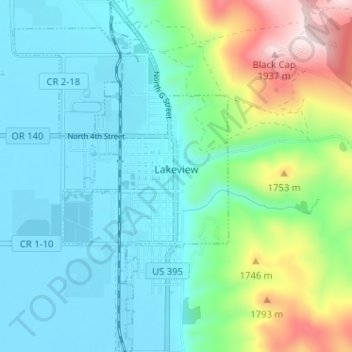
Naam: Topografische kaart Lakeview, hoogte, reliëf.
Locatie: Lakeview, Lake County, Oregon, 97630, United States (42.16423 -120.37558 42.21158 -120.33630)
Gemiddelde hoogte: 1.562 m
Minimale hoogte: 1.440 m
Maximale hoogte: 1.960 m
Lakeview is a town in Lake County, Oregon, United States. The population was 2,418 at the 2020 census. It is the county seat of Lake County. The city bills itself as the "Tallest Town in Oregon" because of its elevation, 4,802 feet (1,464 m) above sea level. Lakeview is situated in the Goose Lake Valley at the foot of the Warner Mountains and at the edge of Oregon's high desert country. Its economy is based on agriculture, lumber production, and government activities. In addition, tourism is an increasingly important part of the city's economy. Oregon's Outback Scenic Byway passes through Lakeview.
Andere topografische kaarten
Klik op een kaart om zijn topografie, zijn hoogte en zijn reliëf te bekijken.
Fort Rock
United States > Oregon > Lake County
Fort Rock, Lake County, Oregon, United States
Gemiddelde hoogte: 1.326 m
Foster Lake
United States > Oregon > Lake County
Foster Lake, Lake County, Oregon, United States
Gemiddelde hoogte: 1.816 m
Christmas Valley
United States > Oregon > Lake County
Christmas Valley, Lake County, Oregon, 97641, United States
Gemiddelde hoogte: 1.316 m
Adel
United States > Oregon > Lake County
Adel, Lake County, Oregon, 97620, United States
Gemiddelde hoogte: 1.467 m
Green Creek
United States > Oregon > Lake County
Green Creek, Lake County, Oregon, United States
Gemiddelde hoogte: 1.657 m