
Topografische kaart Δορούφι Κοιλάδος
Interactieve kaart
Klik op de kaart om de hoogte weer te geven.
Over deze kaart
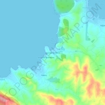
Naam: Topografische kaart Δορούφι Κοιλάδος, hoogte, reliëf.
Gemiddelde hoogte: 30 m
Minimale hoogte: -2 m
Maximale hoogte: 149 m
Andere topografische kaarten
Klik op een kaart om zijn topografie, zijn hoogte en zijn reliëf te bekijken.
Petrothalassa
Greece > Peloponnese, Western Greece and the Ionian > Argolis Regional Unit > Municipal Unit of Kranidi
Petrothalassa, Municipal Unit of Kranidi, Municipality of Ermionida, Argolis Regional Unit, Peloponnese Region, Peloponnese, Western Greece and the Ionian, 213 00, Greece
Gemiddelde hoogte: 24 m
Portocheli
Greece > Peloponnese, Western Greece and the Ionian > Argolis Regional Unit > Municipal Unit of Kranidi
Portocheli, Municipal Unit of Kranidi, Municipality of Ermionida, Argolis Regional Unit, Peloponnese Region, Peloponnese, Western Greece and the Ionian, 213 00, Greece
Gemiddelde hoogte: 19 m
Kranidi
Greece > Peloponnese, Western Greece and the Ionian > Argolis Regional Unit > Municipal Unit of Kranidi
Kranidi, Municipal Unit of Kranidi, Municipality of Ermionida, Argolis Regional Unit, Peloponnese Region, Peloponnese, Western Greece and the Ionian, 213 00, Greece
Gemiddelde hoogte: 77 m