
Topografische kaart Chikkamagaluru
Interactieve kaart
Klik op de kaart om de hoogte weer te geven.
Over deze kaart
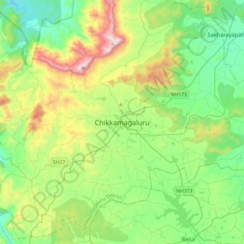
Naam: Topografische kaart Chikkamagaluru, hoogte, reliëf.
Gemiddelde hoogte: 1.052 m
Minimale hoogte: 713 m
Maximale hoogte: 1.883 m
Chikmagalur is situated in the Malenadu region of Karnataka in the Deccan plateau in the foothills of the Western Ghats. It is situated at an elevation of 1,090 metres (3,580 ft) above mean sea level. The Yagachi River has its source near the town and flows in the south-easterly direction before uniting with the Hemavati river. Chikmagalur generally has a moderate to cool climate. The temperature of the city varies from 11-20 °C during winter to 25-32 °C during summer.
Andere topografische kaarten
Klik op een kaart om zijn topografie, zijn hoogte en zijn reliëf te bekijken.
Mullayyanagiri
India > Karnataka > Chikkamagaluru taluku > Chikkamagaluru
Mullayyanagiri, Chikkamagaluru, Chikkamagaluru taluku, Chikkamagaluru district, Karnataka, 577101, India
Gemiddelde hoogte: 1.548 m