
Topografische kaart Selsey
Klik op de kaart om de hoogte weer te geven.
Selsey
A study published by Princeton University and McGill University, in 2020, concluded that the Manhood Peninsula is at particularly high risk of flooding as its topography is less than 5 metres (16 ft) above the current mean sea level and that by 2100 Selsey will be subject to permanent inundation.
Over deze kaart
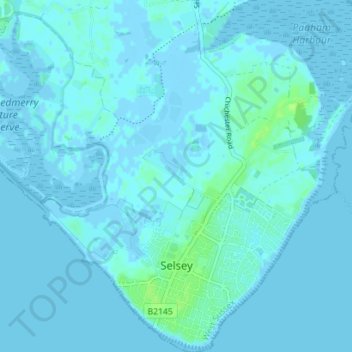
Naam: Topografische kaart Selsey, hoogte, reliëf.
Locatie: Selsey, Chichester, West Sussex, England, United Kingdom (50.72178 -0.81895 50.76629 -0.74938)
Gemiddelde hoogte: 1 m
Minimale hoogte: -4 m
Maximale hoogte: 9 m
Andere topografische kaarten
Klik op een kaart om zijn topografie, zijn hoogte en zijn reliëf te bekijken.
Donnington Park
United Kingdom > England > West Sussex > Chichester > Donnington
Gemiddelde hoogte: 8 m
Horncroft Common Plantation
United Kingdom > England > West Sussex > Chichester
Gemiddelde hoogte: 22 m
Blackdown
United Kingdom > England > West Sussex > Chichester
Blackdown, or Black Down, summit elevation 279.7 metres (918 ft) AMSL, is the highest point in both the historic county of Sussex and the South Downs National Park. It is one of the highest points in the south east of England, exceeded by Walbury Hill, Leith Hill and Pilot Hill. Blackdown is protected as part…
Gemiddelde hoogte: 165 m