
Topografische kaart دهستان لای سیاه
Interactieve kaart
Klik op de kaart om de hoogte weer te geven.
Over deze kaart
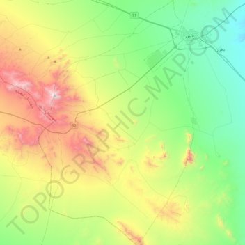
Naam: Topografische kaart دهستان لای سیاه, hoogte, reliëf.
Gemiddelde hoogte: 1.910 m
Minimale hoogte: 1.404 m
Maximale hoogte: 2.936 m
Andere topografische kaarten
Klik op een kaart om zijn topografie, zijn hoogte en zijn reliëf te bekijken.
زندوان
Iran > Isfahan Province > Nain County > دهستان بافران > زندوان
زندوان, دهستان بافران, بخش مرکزی, Nain County, Isfahan Province, Iran
Gemiddelde hoogte: 1.543 m