
Topografische kaart Leelanau County
Interactieve kaart
Klik op de kaart om de hoogte weer te geven.
Over deze kaart
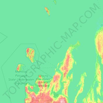
Naam: Topografische kaart Leelanau County, hoogte, reliëf.
Locatie: Leelanau County, Michigan, United States of America (44.77443 -86.15643 45.49144 -85.52684)
Gemiddelde hoogte: 185 m
Minimale hoogte: 166 m
Maximale hoogte: 347 m
Andere topografische kaarten
Klik op een kaart om zijn topografie, zijn hoogte en zijn reliëf te bekijken.
Saint Joseph County
United States of America > Michigan
Saint Joseph County, Michigan, United States of America
Gemiddelde hoogte: 262 m
Bay City
United States of America > Michigan > Bay City
Bay City, Bay County, Michigan, 48708, United States of America
Gemiddelde hoogte: 182 m
Ingham County
United States of America > Michigan
Ingham County, Michigan, United States of America
Gemiddelde hoogte: 278 m
Shiawassee County
United States of America > Michigan
Shiawassee County, Michigan, United States of America
Gemiddelde hoogte: 241 m
Ludington
United States of America > Michigan > Ludington
Ludington, Mason County, Michigan, United States of America
Gemiddelde hoogte: 184 m
Ontonagon County
United States of America > Michigan
Ontonagon County, Michigan, United States of America
Gemiddelde hoogte: 334 m
Lake Saint Clair
United States of America > Michigan > Waldenburg
Lake Saint Clair, Hall Road, Waldenburg, Macomb Township, Macomb County, Michigan, 48044, United States of America
Gemiddelde hoogte: 177 m
Grand Traverse County
United States of America > Michigan
Grand Traverse County, Michigan, United States of America
Gemiddelde hoogte: 246 m
Baraga County
United States of America > Michigan
Baraga County, Michigan, United States of America
Gemiddelde hoogte: 378 m
East Lansing
United States of America > Michigan > East Lansing
East Lansing, Ingham County, Michigan, United States of America
Gemiddelde hoogte: 261 m