
Topografische kaart La Broye
Interactieve kaart
Klik op de kaart om de hoogte weer te geven.
Over deze kaart
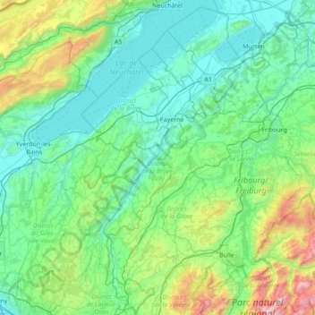
Naam: Topografische kaart La Broye, hoogte, reliëf.
Locatie: La Broye, District de la Broye-Vully, Vaud, 1530, Switzerland (46.52980 6.78783 46.99698 7.11884)
Gemiddelde hoogte: 735 m
Minimale hoogte: 402 m
Maximale hoogte: 2.323 m
Andere topografische kaarten
Klik op een kaart om zijn topografie, zijn hoogte en zijn reliëf te bekijken.
Prévonloup
Switzerland > Vaud > District de la Broye-Vully
Prévonloup, District de la Broye-Vully, Vaud, Switzerland
Gemiddelde hoogte: 744 m
Forel-sur-Lucens
Switzerland > Vaud > District de la Broye-Vully
Forel-sur-Lucens, Lucens, District de la Broye-Vully, Vaud, 1526, Switzerland
Gemiddelde hoogte: 672 m
Payerne
Switzerland > Vaud > District de la Broye-Vully > Payerne
Payerne, District de la Broye-Vully, Vaud, Switzerland
Gemiddelde hoogte: 495 m