
Topografische kaart Charles Town
Interactieve kaart
Klik op de kaart om de hoogte weer te geven.
Over deze kaart
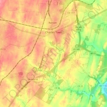
Naam: Topografische kaart Charles Town, hoogte, reliëf.
Locatie: Charles Town, Jefferson County, West Virginia, United States (39.25539 -77.90614 39.29551 -77.81743)
Gemiddelde hoogte: 150 m
Minimale hoogte: 99 m
Maximale hoogte: 182 m
Due to its low elevation for West Virginia, Charles Town is on the northern extent of the Humid Subtropical climate zone, having cool to mildly cold winters and hot and humid summers. Precipitation is evenly distributed throughout the year, providing lush, abundant plant growth.
Andere topografische kaarten
Klik op een kaart om zijn topografie, zijn hoogte en zijn reliëf te bekijken.
Harpers Ferry
United States > West Virginia > Jefferson County
Harpers Ferry, Jefferson County, West Virginia, United States
Gemiddelde hoogte: 174 m
Shepherdstown
United States > West Virginia > Jefferson County
Shepherdstown, Jefferson County, West Virginia, 25443, United States
Gemiddelde hoogte: 126 m
Kearneysville
United States > West Virginia > Jefferson County > Kearneysville
Kearneysville, Jefferson County, West Virginia, 25430-9047, United States
Gemiddelde hoogte: 162 m
Harpers Ferry National Historical Park
United States > West Virginia > Jefferson County > Bolivar
Harpers Ferry National Historical Park, Bolivar, Jefferson County, West Virginia, United States
Gemiddelde hoogte: 161 m
Halltown
United States > West Virginia > Jefferson County > Halltown
Halltown, Jefferson County, West Virginia, 25423, United States
Gemiddelde hoogte: 133 m