
Topografische kaart Blackcomb Glacier
Interactieve kaart
Klik op de kaart om de hoogte weer te geven.
Over deze kaart
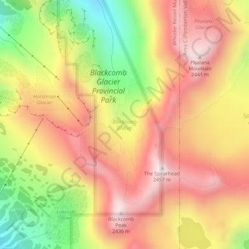
Naam: Topografische kaart Blackcomb Glacier, hoogte, reliëf.
Gemiddelde hoogte: 2.124 m
Minimale hoogte: 1.711 m
Maximale hoogte: 2.434 m
Andere topografische kaarten
Klik op een kaart om zijn topografie, zijn hoogte en zijn reliëf te bekijken.
Blackcomb Peak
Canada > British Columbia > Whistler Resort Municipality
Blackcomb Peak, Whistler Resort Municipality, Squamish-Lillooet Regional District, British Columbia, Canada
Gemiddelde hoogte: 2.103 m
Callaghan Creek
Canada > British Columbia > Whistler Resort Municipality
Callaghan Creek, Whistler Resort Municipality, Squamish-Lillooet Regional District, British Columbia, Canada
Gemiddelde hoogte: 748 m
Decker Glacier
Canada > British Columbia > Whistler Resort Municipality
Decker Glacier, Overlord Trail, Whistler Resort Municipality, Squamish-Lillooet Regional District, British Columbia, Canada
Gemiddelde hoogte: 2.130 m
Spearhead Glacier
Canada > British Columbia > Whistler Resort Municipality
Spearhead Glacier, Decker Loop, Whistler Resort Municipality, Squamish-Lillooet Regional District, British Columbia, Canada
Gemiddelde hoogte: 2.082 m