
Topografische kaart Sandy Hook
Interactieve kaart
Klik op de kaart om de hoogte weer te geven.
Over deze kaart
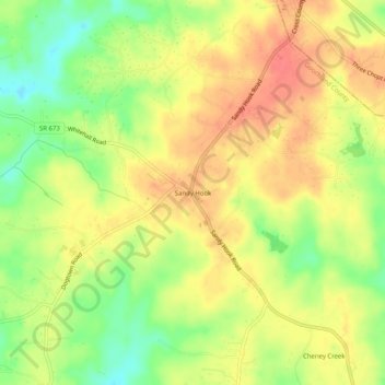
Naam: Topografische kaart Sandy Hook, hoogte, reliëf.
Locatie: Sandy Hook, Goochland County, Virginia, 23153, United States (37.73265 -77.93250 37.77265 -77.89250)
Gemiddelde hoogte: 97 m
Minimale hoogte: 64 m
Maximale hoogte: 121 m
Andere topografische kaarten
Klik op een kaart om zijn topografie, zijn hoogte en zijn reliëf te bekijken.
Manakin Farms
United States > Virginia > Goochland County > Manakin
Manakin Farms, Manakin, Goochland County, Virginia, 23103, United States
Gemiddelde hoogte: 66 m
Three Oaks
United States > Virginia > Goochland County
Three Oaks, Goochland County, Virginia, 23102, United States
Gemiddelde hoogte: 92 m
Shannon Hill
United States > Virginia > Goochland County
Shannon Hill, Goochland County, Virginia, 23084, United States
Gemiddelde hoogte: 139 m
Maidens Forest
United States > Virginia > Goochland County
Maidens Forest, Goochland County, Virginia, 23102, United States
Gemiddelde hoogte: 88 m
Goochland
United States > Virginia > Goochland County > Goochland
Goochland, Goochland County, Virginia, 23014, United States
Gemiddelde hoogte: 74 m
Oaklands
United States > Virginia > Goochland County > Oaklands
Oaklands, Goochland County, Virginia, 23102, United States
Gemiddelde hoogte: 80 m
James River Landing
United States > Virginia > Goochland County > James River Landing
James River Landing, Goochland County, Virginia, United States
Gemiddelde hoogte: 84 m
Amber Lake
United States > Virginia > Goochland County > Amber Lake
Amber Lake, Goochland County, Virginia, 23039, United States
Gemiddelde hoogte: 90 m