
Topografische kaart La Mata
Interactieve kaart
Klik op de kaart om de hoogte weer te geven.
Over deze kaart
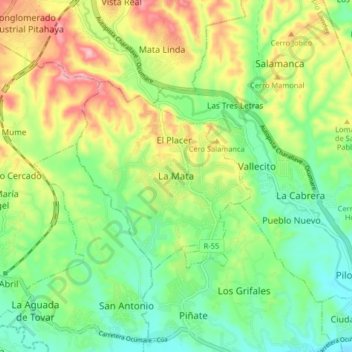
Naam: Topografische kaart La Mata, hoogte, reliëf.
Gemiddelde hoogte: 258 m
Minimale hoogte: 181 m
Maximale hoogte: 384 m
Andere topografische kaarten
Klik op een kaart om zijn topografie, zijn hoogte en zijn reliëf te bekijken.
Parroquia Ocumare del Tuy
Venezuela > Estado Miranda > Municipio Lander
Parroquia Ocumare del Tuy, Municipio Lander, Estado Miranda, Venezuela
Gemiddelde hoogte: 448 m
Tuy
Venezuela > Estado Miranda > Municipio Lander > Los Grifales
Tuy, Los Grifales, Parroquia Santa Bárbara, Municipio Lander, Estado Miranda, 1212, Venezuela
Gemiddelde hoogte: 188 m