
Doe een donatie
Rust jezelf uit voor je volgende avontuur:
Als Amazon-partner verdient deze site een commissie op in aanmerking komende aankopen, zonder extra kosten voor jou.
Topografische kaart Roche Béranger
Klik op de kaart om de hoogte weer te geven.
Doe een donatie
Rust jezelf uit voor je volgende avontuur:
Als Amazon-partner verdient deze site een commissie op in aanmerking komende aankopen, zonder extra kosten voor jou.
Roche Béranger
The road to the ski station starts at Uriage-les-Bains from where the climb is 19 km (12 mi) long, gaining 1,235 m (4,052 ft) in elevation, at an average gradient of 6.5%. There are several sections in excess off 11% in the early stages of the climb. For the Tour de France, the summit is at an elevation of 1,730 m (5,680 ft).
Doe een donatie
Rust jezelf uit voor je volgende avontuur:
Als Amazon-partner verdient deze site een commissie op in aanmerking komende aankopen, zonder extra kosten voor jou.
Over deze kaart
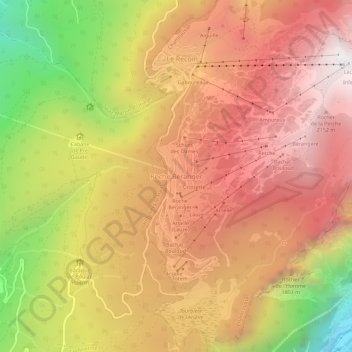
Naam: Topografische kaart Roche Béranger, hoogte, reliëf.
Gemiddelde hoogte: 1.561 m
Minimale hoogte: 539 m
Maximale hoogte: 2.250 m
Doe een donatie
Rust jezelf uit voor je volgende avontuur:
Als Amazon-partner verdient deze site een commissie op in aanmerking komende aankopen, zonder extra kosten voor jou.