
Topografische kaart Devils Lake
Interactieve kaart
Klik op de kaart om de hoogte weer te geven.
Over deze kaart
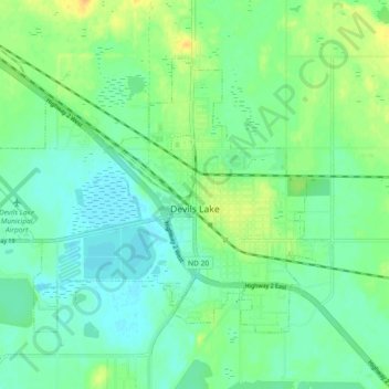
Naam: Topografische kaart Devils Lake, hoogte, reliëf.
Gemiddelde hoogte: 443 m
Minimale hoogte: 433 m
Maximale hoogte: 460 m
The first post office was founded November 15, 1882, and was originally named Creelsburg. It was founded by Lieutenant Heber M. Creel, a West Point graduate and topographical engineer stationed at nearby Fort Totten. After resigning from the U.S. Army, he surveyed the land and established the townsite.
Andere topografische kaarten
Klik op een kaart om zijn topografie, zijn hoogte en zijn reliëf te bekijken.
Channel A
United States > North Dakota > Ramsey County > Grand Harbor
Channel A, Grand Harbor, Ramsey County, North Dakota, United States
Gemiddelde hoogte: 445 m
Six Mile Bay
United States > North Dakota > Ramsey County
Six Mile Bay, Ramsey County, North Dakota, United States
Gemiddelde hoogte: 442 m