
Topografische kaart Anamudi
Interactieve kaart
Klik op de kaart om de hoogte weer te geven.
Over deze kaart
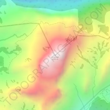
Naam: Topografische kaart Anamudi, hoogte, reliëf.
Gemiddelde hoogte: 2.209 m
Minimale hoogte: 1.703 m
Maximale hoogte: 2.685 m
Anamudi is a mountain located in Ernakulam district and Idukki district of the Indian state of Kerala. It is the highest peak in the Western Ghats and in South India, at an elevation of 2,695 metres (8,842 ft) and a topographic prominence of 2,479 metres (8,133 ft). The name Anamudi literally translates to "elephant's head" a reference to the resemblance of the mountain to an elephant's head. Anamudi is the highest mountain in peninsular India as well as the largest mountain in Kerala. Meanwhile, the highest independent mountain (free-standing mountain) in Kerala is the Cheriyam mountain in Malappuram district. Cheriyam mountain is located at an elevation of 613 m (2,011 ft) above sea level.
Andere topografische kaarten
Klik op een kaart om zijn topografie, zijn hoogte en zijn reliëf te bekijken.
Eravikulam National Park
India > Kerala > Kothamangalam > Idukki
Eravikulam National Park, Idukki, Kothamangalam, Ernakulam district, Kerala, India
Gemiddelde hoogte: 1.704 m