
Topografische kaart Mont Gosford
Interactieve kaart
Klik op de kaart om de hoogte weer te geven.
Over deze kaart
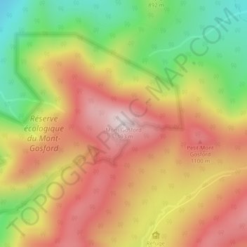
Naam: Topografische kaart Mont Gosford, hoogte, reliëf.
Gemiddelde hoogte: 933 m
Minimale hoogte: 641 m
Maximale hoogte: 1.178 m
Since 1978, Mount Gosford is included in "ZEC Louise-Gosford", a controlled harvesting zone open to the public. Recently, the areas at more than 700 metres of altitude were designated Important Bird Areas due to the presence Bicknell's thrushes, an endemic species living in mountain peaks of northeast North America.