
Topografische kaart Emmett
Interactieve kaart
Klik op de kaart om de hoogte weer te geven.
Over deze kaart
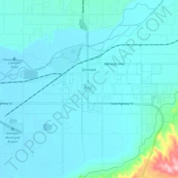
Naam: Topografische kaart Emmett, hoogte, reliëf.
Locatie: Emmett, Gem County, Idaho, United States (43.85026 -116.54272 43.88258 -116.45280)
Gemiddelde hoogte: 738 m
Minimale hoogte: 712 m
Maximale hoogte: 1.000 m
According to the United States Census Bureau, the city has a total area of 2.82 square miles (7.30 km2), of which 2.80 square miles (7.25 km2) is land and 0.02 square miles (0.05 km2) is water. It is located south of the Payette River, at an elevation of 2,362 feet (720 m) above sea level.
Andere topografische kaarten
Klik op een kaart om zijn topografie, zijn hoogte en zijn reliëf te bekijken.
Sweet
United States > Idaho > Gem County
Sweet, Gem County, Idaho, 83670, United States
Gemiddelde hoogte: 811 m