
Topografische kaart Pathankot
Interactieve kaart
Klik op de kaart om de hoogte weer te geven.
Over deze kaart
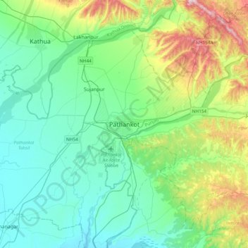
Naam: Topografische kaart Pathankot, hoogte, reliëf.
Gemiddelde hoogte: 379 m
Minimale hoogte: 257 m
Maximale hoogte: 782 m
Pathankot has an average elevation of 332 metres (1,089 ft). It is a green town surrounded by the Ravi and Chakki rivers. Shiwalik foothills on the south and east and snow-capped Himalayas in the back drop in north.
Andere topografische kaarten
Klik op een kaart om zijn topografie, zijn hoogte en zijn reliëf te bekijken.
Sujanpur
India > Punjab > Pathankot Tahsil
Sujanpur, Pathankot Tahsil, Pathankot District, Punjab, 145023, India
Gemiddelde hoogte: 334 m