
Topografische kaart Duck Creek
Interactieve kaart
Klik op de kaart om de hoogte weer te geven.
Over deze kaart
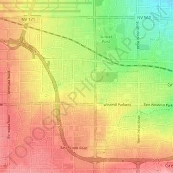
Naam: Topografische kaart Duck Creek, hoogte, reliëf.
Gemiddelde hoogte: 638 m
Minimale hoogte: 583 m
Maximale hoogte: 679 m
Andere topografische kaarten
Klik op een kaart om zijn topografie, zijn hoogte en zijn reliëf te bekijken.
Fire
United States of America > Nevada > Sparks
Fire, Sparks, Washoe County, Nevada, 89431-5025, United States of America
Gemiddelde hoogte: 1.346 m
Calico Basin
United States of America > Nevada > Calico Basin
Calico Basin, Clark County, Nevada, 89161, United States of America
Gemiddelde hoogte: 1.181 m
Currant
United States of America > Nevada > Currant
Currant, Nye County, Nevada, United States of America
Gemiddelde hoogte: 1.598 m
Del Monte
United States of America > Nevada > Del Monte
Del Monte, Mineral County, Nevada, United States of America
Gemiddelde hoogte: 2.289 m
Mud Hills
United States of America > Nevada
Mud Hills, Clark County, Nevada, United States of America
Gemiddelde hoogte: 747 m
Arden
United States of America > Nevada > Enterprise > Arden
Arden, Enterprise, Clark County, Nevada, 89178, United States of America
Gemiddelde hoogte: 759 m