
Topografische kaart Black Butte
Interactieve kaart
Klik op de kaart om de hoogte weer te geven.
Over deze kaart
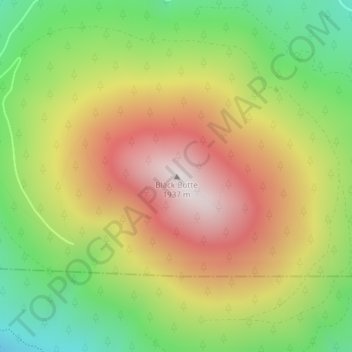
Naam: Topografische kaart Black Butte, hoogte, reliëf.
Locatie: Black Butte, Jefferson County, Oregon, United States (44.40003 -121.63651 44.40013 -121.63641)
Gemiddelde hoogte: 1.514 m
Minimale hoogte: 1.102 m
Maximale hoogte: 1.952 m
According to the U.S. National Geodetic Survey and scientists from the United States Geological Survey, Black Butte has an elevation of 6,436 feet (1,962 m); the Geographic Names Information System database lists its elevation as 6,430 feet (1,960 m), while Oregon Geographic Names lists its elevation at 6,415 feet (1,955 m). The butte has proximal and draping reliefs of 2,490 feet (760 m) and 3,150 feet (960 m), which are the "difference between summit elevation and that of highest exposure of older rocks overlain by the edifice" and the "difference between summit elevation and that of lowest distal lavas of the edifice (not including distal pyroclastic or debris flows)," respectively. According to E. M. Taylor, Black Butte has a diameter of 4 miles (6.4 km).
Andere topografische kaarten
Klik op een kaart om zijn topografie, zijn hoogte en zijn reliëf te bekijken.
Culver
United States > Oregon > Jefferson County
Culver, Jefferson County, Oregon, United States
Gemiddelde hoogte: 807 m
Lake Billy Chinook
United States > Oregon > Jefferson County
Lake Billy Chinook, Jefferson County, Oregon, United States
Gemiddelde hoogte: 776 m
Madras
United States > Oregon > Jefferson County
Madras, Jefferson County, Oregon, United States
Gemiddelde hoogte: 739 m
Camp Sherman
United States > Oregon > Jefferson County
Camp Sherman, Jefferson County, Oregon, 97730, United States
Gemiddelde hoogte: 939 m
Crooked River Ranch
United States > Oregon > Jefferson County
Crooked River Ranch, Jefferson County, Oregon, United States
Gemiddelde hoogte: 825 m
Peter Skene Ogden State Scenic Viewport
United States > Oregon > Jefferson County
Peter Skene Ogden State Scenic Viewport, Jefferson County, Oregon, United States
Gemiddelde hoogte: 839 m
Warm Springs
United States > Oregon > Jefferson County > Warm Springs
Warm Springs, Jefferson County, Oregon, 97761, United States
Gemiddelde hoogte: 650 m
Mount Jefferson
United States > Oregon > Jefferson County
Mount Jefferson, Jefferson County, Oregon, United States
Gemiddelde hoogte: 2.537 m