
Topografische kaart Sebastopol
Interactieve kaart
Klik op de kaart om de hoogte weer te geven.
Over deze kaart
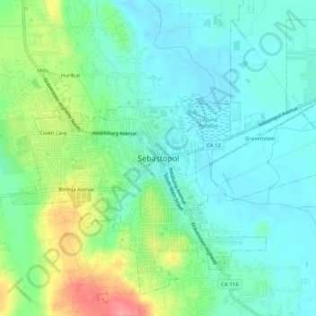
Naam: Topografische kaart Sebastopol, hoogte, reliëf.
Gemiddelde hoogte: 41 m
Minimale hoogte: 14 m
Maximale hoogte: 108 m
Sebastopol's elevation is 65 to 250 feet (20 to 76 meters) above sea level. Its downtown is at the intersection of State Route 12 and State Route 116 (Gravenstein Highway), approximately 9 mi (14 km) west of U.S. Route 101.