
Topografische kaart Madison
Interactieve kaart
Klik op de kaart om de hoogte weer te geven.
Over deze kaart
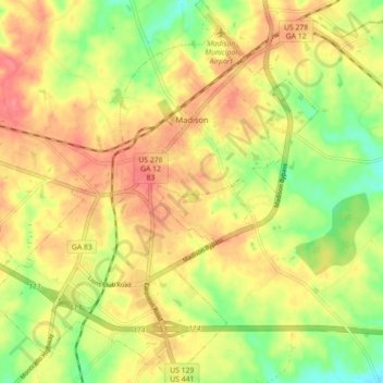
Naam: Topografische kaart Madison, hoogte, reliëf.
Locatie: Madison, Morgan County, Georgia, United States (33.54487 -83.51538 33.61875 -83.43872)
Gemiddelde hoogte: 195 m
Minimale hoogte: 156 m
Maximale hoogte: 225 m
Madison is located at 33°35′17″N 83°28′21″W / 33.58806°N 83.47250°W / 33.58806; -83.47250 (33.588038, -83.472368). According to the United States Census Bureau, the city has a total area of 8.9 square miles (23 km2), of which, 8.9 square miles (23 km2) of it is land and 0.04 square miles (0.10 km2) of it (0.45%) is water. Madison is situated on a high ridge which traverses Morgan County from the northeast to the southwest at an elevation of 760 feet.
Andere topografische kaarten
Klik op een kaart om zijn topografie, zijn hoogte en zijn reliëf te bekijken.
Bostwick
United States > Georgia > Morgan County
Bostwick, Morgan County, Georgia, United States
Gemiddelde hoogte: 221 m
Rutledge
United States > Georgia > Morgan County
Rutledge, Morgan County, Georgia, United States
Gemiddelde hoogte: 211 m
Fairplay
United States > Georgia > Morgan County
Fairplay, Morgan County, Georgia, United States
Gemiddelde hoogte: 223 m