
Doe een donatie
Rust jezelf uit voor je volgende avontuur:
Als Amazon-partner verdient deze site een commissie op in aanmerking komende aankopen, zonder extra kosten voor jou.
Topografische kaart Henry Mountains
Klik op de kaart om de hoogte weer te geven.
Doe een donatie
Rust jezelf uit voor je volgende avontuur:
Als Amazon-partner verdient deze site een commissie op in aanmerking komende aankopen, zonder extra kosten voor jou.
Over deze kaart
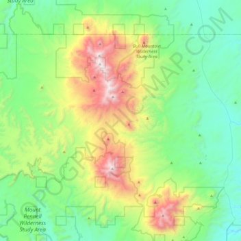
Naam: Topografische kaart Henry Mountains, hoogte, reliëf.
Locatie: Henry Mountains, Garfield County, Utah, United States (37.84938 -110.89874 38.20150 -110.60211)
Gemiddelde hoogte: 1.936 m
Minimale hoogte: 1.346 m
Maximale hoogte: 3.502 m
Doe een donatie
Rust jezelf uit voor je volgende avontuur:
Als Amazon-partner verdient deze site een commissie op in aanmerking komende aankopen, zonder extra kosten voor jou.
Andere topografische kaarten
Klik op een kaart om zijn topografie, zijn hoogte en zijn reliëf te bekijken.
Bryce Canyon National Park
United States > Utah > Garfield County
Bryce Canyon National Park (/braɪs/) is an American national park located in southwestern Utah. The major feature of the park is Bryce Canyon, which despite its name, is not a canyon, but a collection of giant natural amphitheaters along the eastern side of the Paunsaugunt Plateau. Bryce is distinctive due to…
Gemiddelde hoogte: 2.259 m
Mount Ellen
United States > Utah > Garfield County
Mount Ellen is an ultra prominent peak, meaning that it has more than 1,500 metres (4,921 ft) of topographic prominence, standing out considerably from nearby mountains. It stands in the watershed of the Fremont River, which together with Muddy Creek forms the Dirty Devil River, which drains into the Colorado…
Gemiddelde hoogte: 3.149 m
Doe een donatie
Rust jezelf uit voor je volgende avontuur:
Als Amazon-partner verdient deze site een commissie op in aanmerking komende aankopen, zonder extra kosten voor jou.
Escalante Petrified Forest State Park
United States > Utah > Garfield County > Escalante
Gemiddelde hoogte: 1.832 m
Doe een donatie
Rust jezelf uit voor je volgende avontuur:
Als Amazon-partner verdient deze site een commissie op in aanmerking komende aankopen, zonder extra kosten voor jou.
Bryce Canyon National Park
United States > Utah > Garfield County
Bryce Canyon National Park (/braɪs/) is an American national park located in southwestern Utah. The major feature of the park is Bryce Canyon, which despite its name, is not a canyon, but a collection of giant natural amphitheaters along the eastern side of the Paunsaugunt Plateau. Bryce is distinctive due to…
Gemiddelde hoogte: 2.259 m
Doe een donatie
Rust jezelf uit voor je volgende avontuur:
Als Amazon-partner verdient deze site een commissie op in aanmerking komende aankopen, zonder extra kosten voor jou.
Panguitch
United States > Utah > Garfield County
Panguitch has a cool semi-arid climate (Köppen BSk) with summers featuring hot afternoons and cold mornings, and cold, dry winters. The high altitude and relatively high latitude means that mornings are cold throughout the year and freezing for most of it: between 1971 and 2000 an average of 227.7 mornings…
Gemiddelde hoogte: 2.043 m
Doe een donatie
Rust jezelf uit voor je volgende avontuur:
Als Amazon-partner verdient deze site een commissie op in aanmerking komende aankopen, zonder extra kosten voor jou.