
Topografische kaart Pasaia
Interactieve kaart
Klik op de kaart om de hoogte weer te geven.
Over deze kaart
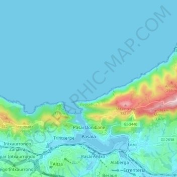
Naam: Topografische kaart Pasaia, hoogte, reliëf.
Gemiddelde hoogte: 40 m
Minimale hoogte: -2 m
Maximale hoogte: 332 m
Andere topografische kaarten
Klik op een kaart om zijn topografie, zijn hoogte en zijn reliëf te bekijken.
Oiartzun
Spain > Autonomous Community of the Basque Country > Donostialdea
Oiartzun, Donostialdea, Gipuzkoa, Autonomous Community of the Basque Country, 20180, Spain
Gemiddelde hoogte: 251 m
Donostia / San Sebastián
Spain > Autonomous Community of the Basque Country > Donostialdea > Donostia / San Sebastián
Donostia / San Sebastián, San Sebastián, Donostialdea, Gipuzkoa, Autonomous Community of the Basque Country, 20003, Spain
Gemiddelde hoogte: 134 m
Zikuñaga
Spain > Autonomous Community of the Basque Country > Donostialdea > Hernani > Zikuñaga
Zikuñaga, Hernani, Donostialdea, Gipuzkoa, Autonomous Community of the Basque Country, 20120, Spain
Gemiddelde hoogte: 62 m
Usurbil
Spain > Autonomous Community of the Basque Country > Donostialdea
Usurbil, Donostialdea, Gipuzkoa, Autonomous Community of the Basque Country, 20170, Spain
Gemiddelde hoogte: 138 m
Errenteria
Spain > Autonomous Community of the Basque Country > Donostialdea
Errenteria, Donostialdea, Gipuzkoa, Autonomous Community of the Basque Country, 20100, Spain
Gemiddelde hoogte: 190 m