
Topografische kaart Matiyal
Interactieve kaart
Klik op de kaart om de hoogte weer te geven.
Over deze kaart
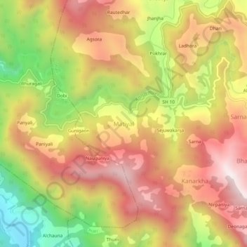
Naam: Topografische kaart Matiyal, hoogte, reliëf.
Locatie: Matiyal, Dhari, Nainital, Uttarakhand, India (29.35681 79.59104 29.39681 79.63104)
Gemiddelde hoogte: 1.726 m
Minimale hoogte: 1.202 m
Maximale hoogte: 2.128 m
Andere topografische kaarten
Klik op een kaart om zijn topografie, zijn hoogte en zijn reliëf te bekijken.
Mukteshwar
India > Uttarakhand > Dhari
Mukteshwar, Dhari, Nainital, Uttarakhand, 263138, India
Gemiddelde hoogte: 1.982 m