
Topografische kaart Buffalo
Interactieve kaart
Klik op de kaart om de hoogte weer te geven.
Over deze kaart
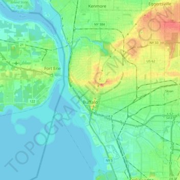
Naam: Topografische kaart Buffalo, hoogte, reliëf.
Locatie: Buffalo, Erie County, New York, United States (42.82601 -78.92236 42.96645 -78.79512)
Gemiddelde hoogte: 185 m
Minimale hoogte: 172 m
Maximale hoogte: 220 m
The Buffalo metropolitan area is on the Erie/Ontario Lake Plain of the Eastern Great Lakes Lowlands, a narrow plain extending east to Utica, New York. The city is generally flat, except for elevation changes in the University Heights and Fruit Belt neighborhoods. The Southtowns are hillier, leading to the Cattaraugus Hills in the Appalachian Upland. Several types of shale, limestone and lagerstätten are prevalent in Buffalo and its surrounding area, lining their stream beds.
Andere topografische kaarten
Klik op een kaart om zijn topografie, zijn hoogte en zijn reliëf te bekijken.
East Aurora
United States > New York > Erie County
East Aurora, Town of Aurora, Erie County, New York, 14052, United States
Gemiddelde hoogte: 283 m
Sandy Beach
United States > New York > Erie County > Town of Grand Island
Sandy Beach, Town of Grand Island, Erie County, New York, 14304, United States
Gemiddelde hoogte: 175 m
Wolcottsburg
United States > New York > Erie County > Town of Clarence
Wolcottsburg, Town of Clarence, Newstead, Erie County, New York, 14032, United States
Gemiddelde hoogte: 180 m
Town of Tonawanda
United States > New York > Erie County
Town of Tonawanda, Erie County, New York, United States
Gemiddelde hoogte: 183 m
South Wales
United States > New York > Erie County
South Wales, Town of Wales, Erie County, New York, 14139, United States
Gemiddelde hoogte: 361 m
Village of Williamsville
United States > New York > Erie County > Town of Amherst
Village of Williamsville, Town of Amherst, Erie County, New York, United States
Gemiddelde hoogte: 206 m
East Amherst
United States > New York > Erie County > Town of Clarence
East Amherst, Town of Clarence, Erie County, New York, 14051, United States
Gemiddelde hoogte: 183 m
Town of Cheektowaga
United States > New York > Erie County
Town of Cheektowaga, Erie County, New York, United States
Gemiddelde hoogte: 201 m
Town of Clarence
United States > New York > Erie County
Town of Clarence, Erie County, New York, United States
Gemiddelde hoogte: 200 m
Town of Amherst
United States > New York > Erie County
Town of Amherst, Erie County, New York, United States
Gemiddelde hoogte: 184 m
Village of Hamburg
United States > New York > Erie County > Town of Hamburg
Village of Hamburg, Town of Hamburg, Erie County, New York, United States
Gemiddelde hoogte: 245 m
Town of Lancaster
United States > New York > Erie County
Town of Lancaster, Erie County, New York, United States
Gemiddelde hoogte: 214 m
Kenilworth
United States > New York > Erie County > Tonawanda Town CDP
Kenilworth, Tonawanda Town CDP, Erie County, New York, 14223, United States
Gemiddelde hoogte: 192 m
Orchard Park
United States > New York > Erie County > Orchard Park
Orchard Park, Erie County, New York, 14127, United States
Gemiddelde hoogte: 262 m
Colden
United States > New York > Erie County > Colden
Colden, Town of Colden, Erie County, New York, 14033, United States
Gemiddelde hoogte: 414 m
Lackawanna
United States > New York > Erie County > Lackawanna
Lackawanna, Erie County, New York, United States
Gemiddelde hoogte: 183 m
Glen Falls
United States > New York > Erie County > Williamsville
Glen Falls, Williamsville, Amherst, Erie County, New York, 14221-5323, United States
Gemiddelde hoogte: 202 m
Ferry Village
United States > New York > Erie County > Ferry Village
Ferry Village, Grand Island, Erie County, New York, 14072, United States
Gemiddelde hoogte: 177 m