
Doe een donatie
Rust jezelf uit voor je volgende avontuur:
Als Amazon-partner verdient deze site een commissie op in aanmerking komende aankopen, zonder extra kosten voor jou.
Topografische kaart Beaver Creek
Klik op de kaart om de hoogte weer te geven.
Doe een donatie
Rust jezelf uit voor je volgende avontuur:
Als Amazon-partner verdient deze site een commissie op in aanmerking komende aankopen, zonder extra kosten voor jou.
Beaver Creek
Like most of Yukon, Beaver Creek has a subarctic climate (Dfc), and NRC Plant Hardiness Zone of 0a. It is situated at an elevation of approximately 650 m (2,130 ft). Beaver Creek experiences annual temperature average daily highs of 20 °C (68 °F) in July and average daily lows of −30 °C (−22 °F) in January. Record high temperature was 32.8 °C (91.0 °F) on June 15, 1969, and the lowest was −55.0 °C (−67.0 °F) on January 17, 1971. Beaver Creek has an average annual snowfall of 117.9 cm (46.42 in) and 298.6 mm (11.76 in) of rainfall.
Doe een donatie
Rust jezelf uit voor je volgende avontuur:
Als Amazon-partner verdient deze site een commissie op in aanmerking komende aankopen, zonder extra kosten voor jou.
Over deze kaart
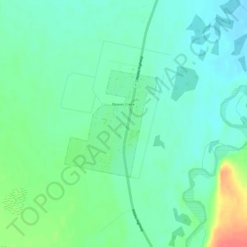
Naam: Topografische kaart Beaver Creek, hoogte, reliëf.
Locatie: Beaver Creek, Yukon, Canada (62.37597 -140.89129 62.38767 -140.86934)
Gemiddelde hoogte: 662 m
Minimale hoogte: 646 m
Maximale hoogte: 703 m
Doe een donatie
Rust jezelf uit voor je volgende avontuur:
Als Amazon-partner verdient deze site een commissie op in aanmerking komende aankopen, zonder extra kosten voor jou.