
Topografische kaart Rural Municipality of East St. Paul
Interactieve kaart
Klik op de kaart om de hoogte weer te geven.
Over deze kaart
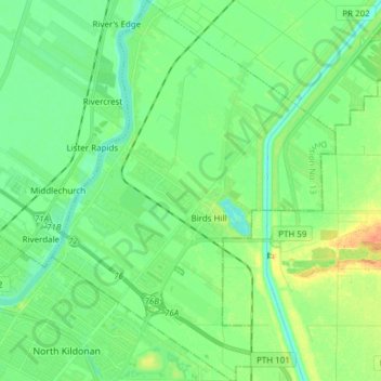
Naam: Topografische kaart Rural Municipality of East St. Paul, hoogte, reliëf.
Gemiddelde hoogte: 233 m
Minimale hoogte: 221 m
Maximale hoogte: 257 m
Andere topografische kaarten
Klik op een kaart om zijn topografie, zijn hoogte en zijn reliëf te bekijken.
Libau
Canada > Manitoba > Division No. 13 > Rural Municipality of St. Clements
Libau, Rural Municipality of St. Clements, Division No. 13, Manitoba, Canada
Gemiddelde hoogte: 223 m
Clandeboye
Canada > Manitoba > Division No. 13
Clandeboye, Rural Municipality of St. Andrews, Division No. 13, Manitoba, R0C 0P0, Canada
Gemiddelde hoogte: 226 m
East Selkirk
Canada > Manitoba > Division No. 13 > Rural Municipality of St. Clements
East Selkirk, Rural Municipality of St. Clements, Division No. 13, Manitoba, R0E 0M0, Canada
Gemiddelde hoogte: 227 m
Lockport
Canada > Manitoba > Division No. 13 > Rural Municipality of St. Andrews
Lockport, Rural Municipality of St. Andrews, Division No. 13, Manitoba, R1A 3H6, Canada
Gemiddelde hoogte: 232 m
Selkirk
Canada > Manitoba > Division No. 13
Selkirk, Division No. 13, Manitoba, Canada
Gemiddelde hoogte: 227 m