
Topografische kaart Mackenzie River
Interactieve kaart
Klik op de kaart om de hoogte weer te geven.
Over deze kaart
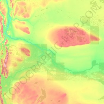
Naam: Topografische kaart Mackenzie River, hoogte, reliëf.
Gemiddelde hoogte: 338 m
Minimale hoogte: 93 m
Maximale hoogte: 1.464 m
The Mackenzie widens considerably to about 6 to 7 km (3.7 to 4.3 mi) at Norman Wells, a major center of oil production. There is a narrows at the Mountain River confluence called the Sans Sault Rapids, where the Mackenzie falls about 6 metres (20 ft). Below the Mountain River the Mackenzie flows due north until reaching The Ramparts, a limestone gorge barely 500 metres (1,600 ft) wide and up to 45 metres (148 ft) deep. Below The Ramparts is the village of Fort Good Hope, where the Mackenzie turns northwest again, soon crossing the Arctic Circle. The Mackenzie here flows slightly lower in elevation than the surrounding tundra, as a braided river between low bluffs about 3 to 5 km (1.9 to 3.1 mi) apart. It receives the Arctic Red River from the southwest at Tsiigehtchic, where traffic on the Dempster Highway crosses via ferry/ice bridge.
Andere topografische kaarten
Klik op een kaart om zijn topografie, zijn hoogte en zijn reliëf te bekijken.
Fort Simpson
Canada > Northwest Territories > Dehcho Region
Fort Simpson, Dehcho Region, Northwest Territories, X0E 0N0, Canada
Gemiddelde hoogte: 135 m
Nahanni National Park Reserve of Canada
Canada > Northwest Territories > Dehcho Region
Nahanni National Park Reserve of Canada, Dehcho Region, Northwest Territories, Canada
Gemiddelde hoogte: 1.145 m
Cli Lake
Canada > Northwest Territories > Dehcho Region
Cli Lake, Dehcho Region, Northwest Territories, Canada
Gemiddelde hoogte: 322 m
Fort Simpson
Canada > Northwest Territories > Dehcho Region > Fort Simpson
Fort Simpson, Dehcho Region, Northwest Territories, Canada
Gemiddelde hoogte: 155 m