
Topografische kaart Sakib
Interactieve kaart
Klik op de kaart om de hoogte weer te geven.
Over deze kaart
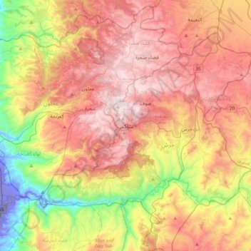
Naam: Topografische kaart Sakib, hoogte, reliëf.
Gemiddelde hoogte: 639 m
Minimale hoogte: -254 m
Maximale hoogte: 1.244 m
Sakib is situated on the East Bank Plateau. Originally, the city had been built on Mountains. Sakib's terrain is typified by its mountains, and the area's elevation ranges from 900 to 1,200 m. Jerash is located to the east, Irbid io the north, Zarqa to the southeast and the capital Amman is to Sakib's south.
Andere topografische kaarten
Klik op een kaart om zijn topografie, zijn hoogte en zijn reliëf te bekijken.
الحداده
Jordan > Jarash > Jerash Sub-District > الحداده
الحداده, Jerash Sub-District, Qasabah Jerash, Jarash, 26111, Jordan
Gemiddelde hoogte: 579 m