
Doe een donatie
Rust jezelf uit voor je volgende avontuur:
Als Amazon-partner verdient deze site een commissie op in aanmerking komende aankopen, zonder extra kosten voor jou.
Topografische kaart Vișeu de Sus
Klik op de kaart om de hoogte weer te geven.
Doe een donatie
Rust jezelf uit voor je volgende avontuur:
Als Amazon-partner verdient deze site een commissie op in aanmerking komende aankopen, zonder extra kosten voor jou.
Vișeu de Sus
Vișeu de Sus is located in the northeastern part of Maramureș County, on the border with Ukraine. The town lies at the confluence of the rivers Vișeu and Vaser, at an altitude of 427 m (1,401 ft) above sea level, having the characteristics of a mountain city. It neighbors the communes of Moisei to the southeast, Vișeu de Jos to the west, and Poienile de sub Munte to the northwest. It also borders Maramureș Mountains Natural Park to the north, and Rodna Mountains National Park to the south-east. The town administers a surface area of 44,306 ha (109,480 acres), making it the second-largest town by area in Romania.
Doe een donatie
Rust jezelf uit voor je volgende avontuur:
Als Amazon-partner verdient deze site een commissie op in aanmerking komende aankopen, zonder extra kosten voor jou.
Over deze kaart
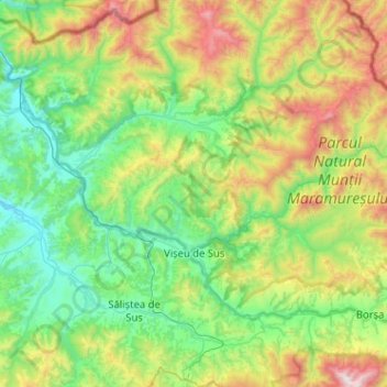
Naam: Topografische kaart Vișeu de Sus, hoogte, reliëf.
Locatie: Vișeu de Sus, Maramureș, Romania (47.65891 24.37557 47.86529 24.88777)
Gemiddelde hoogte: 865 m
Minimale hoogte: 348 m
Maximale hoogte: 2.266 m
Doe een donatie
Rust jezelf uit voor je volgende avontuur:
Als Amazon-partner verdient deze site een commissie op in aanmerking komende aankopen, zonder extra kosten voor jou.
Andere topografische kaarten
Klik op een kaart om zijn topografie, zijn hoogte en zijn reliëf te bekijken.
Doe een donatie
Rust jezelf uit voor je volgende avontuur:
Als Amazon-partner verdient deze site een commissie op in aanmerking komende aankopen, zonder extra kosten voor jou.
Doe een donatie
Rust jezelf uit voor je volgende avontuur:
Als Amazon-partner verdient deze site een commissie op in aanmerking komende aankopen, zonder extra kosten voor jou.
Doe een donatie
Rust jezelf uit voor je volgende avontuur:
Als Amazon-partner verdient deze site een commissie op in aanmerking komende aankopen, zonder extra kosten voor jou.
Doe een donatie
Rust jezelf uit voor je volgende avontuur:
Als Amazon-partner verdient deze site een commissie op in aanmerking komende aankopen, zonder extra kosten voor jou.
Doe een donatie
Rust jezelf uit voor je volgende avontuur:
Als Amazon-partner verdient deze site een commissie op in aanmerking komende aankopen, zonder extra kosten voor jou.