
Topografische kaart Baguio
Interactieve kaart
Klik op de kaart om de hoogte weer te geven.
Over deze kaart
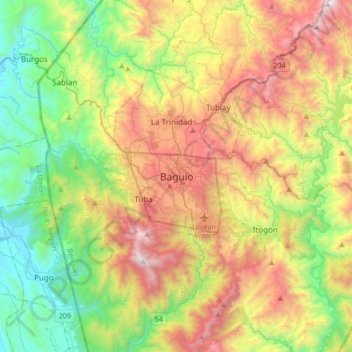
Naam: Topografische kaart Baguio, hoogte, reliëf.
Gemiddelde hoogte: 882 m
Minimale hoogte: 24 m
Maximale hoogte: 2.226 m
In 1903, Filipinos, Japanese and Chinese workers were hired to build Kennon Road, the first road directly connecting Baguio with the lowlands of La Union and Pangasinan. Before this, the only road to Benguet was Naguilian Road, and it was largely a horse trail at higher elevations. Camp John Hay was established on October 25, 1903 after President Theodore Roosevelt signed an executive order setting aside land in Benguet for a military reservation for the United States Army. It was named after Roosevelt's Secretary of State, John Milton Hay.