
Topografische kaart Fort Garland
Interactieve kaart
Klik op de kaart om de hoogte weer te geven.
Over deze kaart
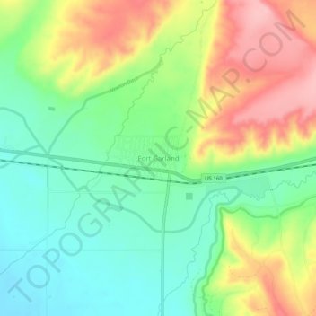
Naam: Topografische kaart Fort Garland, hoogte, reliëf.
Gemiddelde hoogte: 2.441 m
Minimale hoogte: 2.380 m
Maximale hoogte: 2.530 m
Fort Garland is located at an elevation of 7,936 ft (2,419 m) in northern Costilla County. Fort Garland is at the crossroads of U.S. Route 160 and Colorado State Highway 159, which leads south towards Taos and Santa Fe, New Mexico. The town of Blanca is 4 miles (6.4 km) west on U.S. Route 160. Walsenburg is 47 miles (76 km) to the east, across the Sangre de Cristo Range.
Andere topografische kaarten
Klik op een kaart om zijn topografie, zijn hoogte en zijn reliëf te bekijken.
Fort Garland
United States > Colorado > Costilla County
Fort Garland, Costilla County, Colorado, United States
Gemiddelde hoogte: 2.427 m
Forbes Park Dam
United States > Colorado > Costilla County
Forbes Park Dam, Costilla County, Colorado, United States
Gemiddelde hoogte: 2.958 m
Red Mountain
United States > Colorado > Costilla County
Red Mountain, Costilla County, Colorado, United States
Gemiddelde hoogte: 3.862 m
Blanca
United States > Colorado > Costilla County
Blanca, Costilla County, Colorado, United States
Gemiddelde hoogte: 2.366 m
San Luis
United States > Colorado > Costilla County
San Luis, Costilla County, Colorado, 81152, United States
Gemiddelde hoogte: 2.448 m
San Acacio
United States > Colorado > Costilla County
San Acacio, Costilla County, Colorado, United States
Gemiddelde hoogte: 2.354 m
Culebra Peak
United States > Colorado > Costilla County
Culebra Peak, Costilla County, Colorado, United States
Gemiddelde hoogte: 3.920 m