
Topografische kaart Keystone Lake
Interactieve kaart
Klik op de kaart om de hoogte weer te geven.
Over deze kaart
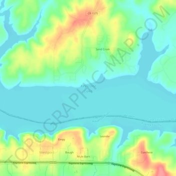
Naam: Topografische kaart Keystone Lake, hoogte, reliëf.
Gemiddelde hoogte: 241 m
Minimale hoogte: 218 m
Maximale hoogte: 292 m
The spillway is a gated ogee weir, 720 feet (220 m) wide with eighteen tainter gates, each 40 by 35 feet (12 by 11 m). Spillway capacity at the maximum pool level (elevation 766.0 feet (233.5 m)) is 939,000 cubic feet per second (26,600 m3/s). Capacity at the top of the flood control pool level (elevation 754.0 feet (229.8 m)) is 565,000 cubic feet per second (16,000 m3/s). The spillway also has nine sluices, each 5.67 by 10 feet (1.73 by 3.05 m).